The latest report, from the Road Safety Foundation and Ageas Insurance says that the pandemic has presented a unique chance to re-shape travel patterns and support healthier travel choices, which in turn will cut casualty numbers and help to achieve health, exercise, net-zero carbon and air quality goals.
The annual report always looks at the most dangerous roads which we’ve taken a closer look at here.
The riskiest roads
To see just how risky the roads near you are, visit our interactive Dangerous Roads Map, created in partnership with the Road Safety Foundation. Using the data from the report, it's a great tool to help you plan your journey, as it shows Britain’s riskiest motorways and ‘A’ roads.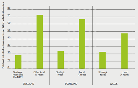
The crash rate on the strategic and major road networks are much lower than on local ‘A’ roads – the busiest and fastest roads in England, Scotland and Wales are, by design, relatively safe.
Britain’s Top 10 most improved roads
The report identifies twenty six roads as the most improved for fatal and serious accidents between 2017-19 when compared to the period 2014-16, we've highlighted the top ten below.
|
Road |
Road Authority/ies |
Section of road |
Decrease in crashes |
|---|---|---|---|
|
A11 |
Bracknell Forest ` (On the Major Road Network) |
Between the A14 near Newmarket and the A134 north of Thetford | 70% |
| M6 | Highways England (On the Strategic Road Network) |
Between junction 0 with the M1 and junction 4a with the M42 near Birmingham | 53% |
| A167 | Gateshead (93%) Newcastle upon Tyne (7%) |
Between the roundabout with the A1 near Low Eighton and the junction with the A167(M) and the A186 in Newcastle Upon Tyne |
68% |
|
M40 |
Highways England (On the Strategic Road Network) |
Between junction 4 with the A404 near High Wycombe and junction 9 with the A34 near Bicester |
51% |
|
A1124 |
Essex | Between the A12 west of Colchester and the Box Mill Plantation near Halstead |
78% |
|
A688 |
Durham | Between the A67 at Barnard Castle and the A68 at West Auckland |
85% |
|
A5061 |
Warrington | Between the A49 in Warrington and the A50 |
85% |
|
A726 |
South Lanarkshire | Between the A71 in Strathaven and the A725 in East Kilbride |
78% |
|
A652 |
Kirklees (On the Major Road Network) |
Between the A638 in Dewsbury and the A651 near the M62 |
69% |
|
A4 |
Bath and North East Somerset (86%) Bristol, City of (14%) (On the Major Road Network) |
Between the river north-west of Bath and the A4174 near Bristol |
66% |
View the Report: Building Back Safer: Making roads fit for 2030